By Tim Rohr
As Typhoon Mawar was approaching Guam, it intensified to a Supertyphoon with gusts up to 175mph and was making a beeline for my home in Agat. While my home has been through such winds before (Paka and Pongsana), that was awhile ago, and I had some other special reasons for being concerned about my home this time around.
So, like many, if not most of you, I spent some extra time on my knees (as I did in Paka and Pongsana), praying that the wrath of Mawar might be turned away, or at least just a bit. And that's what happened, as described by meteorologist, Mike Middlebrooke, in this Facebook post. Thank you Mike for saying it like you said it.
Below is copied the full text of Mike's post in case you can't link to the above, with his pics inserted:
All those who prayed prior to and during the passage of Typhoon Mawar across Guam might be interested to know that in response to the prayers of many, Mawar went from being a 155 mph super typhoon out ESE of Guam down to a 135-140 mph non-super typhoon just east of the island before crossing the north tip of Guam at that lesser intensity. Once Mawar got safely west of Guam, it intensified again and as I write this (Thu 11 PM CDT) it is now a Cat 5 super typhoon with max winds of 185 mph.
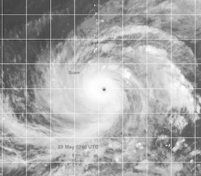
The first picture shows STY Mawar ESE of Guam Tue 23 May at 240 AM CDT, 540 PM Tue at Guam, with max winds of 155 mph.
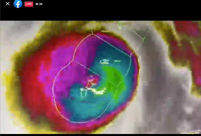
The second picture is a screen grab from an excellent live briefing on FB by the Warning Coordination Meterologist for Guam, Landon Aydlett. It is an enhanced IR satellite image of Mawar in which the eye has deteriorated significantly, indicating weakening, and is now crossing the northern tip of Guam.
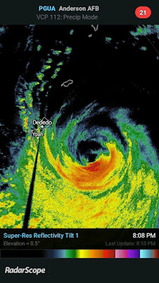
From the radar image in the third picture it appears that there was a massive intrusion of dry air into the eye from the north, wiping out the northern half of the eyewall. This is NOT the radar signature of a STY, and at this point JTWC had downgraded Mawar to a non-super typhoon with max winds at 120 kt, or 138 mph. (The lower limit for super is 130 kt, 150 mph.) But the strongest winds of 130-140 mph were in the heavy rain band south of the center, and Mawar dragged those winds and the heavy rain over the island, resulting, as everyone on Guam knows, in considerable damage and flooding.
In the last image, from the 25th at 11 AM CDT, 26th at 2 AM on Guam, we see STY Mawar has intensified rapidly since leaving Guam behind, and had winds of 170 mph at image time. As indicated earlier, now those winds are assessed at 185 mph.
So what does this all mean?
1. Well, hundreds or even thousands of God's people were praying for Guam, that Mawar would weaken or shift course or do both. Mawar weakened just in time to spare Guam the terrible destruction of a 160 mph STY in favor of a lesser 135-140 mph storm.
2. As bad as Typhoon Mawar was, it could have been A LOT WORSE, and I think a miracle occurred. I can't imagine what it would be like if Mawar had passed over Guam at, say, 185 mph!
3. But having said that, we also see that a 140 mph typhoon can still do a lot of damage and be very dangerous even if it isn't super.
We should give thanks to the Lord and praise Him for the way things turned out! Now we all need to pray for a fast recovery, with power and water restored as soon as possible. God bless all of you on Guam; we are still praying.
+++++


All our prayers, most especially with the unwavering intercession of our dear mother and protector Santa Marian Kamalen. Ora pro nobis 🙏
ReplyDelete